Cars are still the number one mode of transportation in Germany, in spite of their high carbon emissions. To make eco-friendlier alternatives more attractive, researchers from the Fraunhofer Institute of Optronics, System Technologies and Image Exploitation (IOSB) are working with partners in the DAKIMO (Data and AI as enablers for sustainable, intermodal mobility) project to develop intelligent, intermodal transportation. An AI for multimodal route planning is being developed to help get people to where they are going seamlessly, conveniently, and reliably — and all without privately owned cars.
Eco-friendly transportation is possible via a variety of means, including buses, trains, trams, electric scooters, and shared bikes. Public transit has significantly less environmental impact than personal cars. Even so, cars are still the dominant mode of transportation. After all, they are always available, and planning trips by vehicle is easy.
For public transit to become an attractive alternative, it must be possible to easily combine different means of transportation along a certain route, and switching between public transportation, bikes (especially shared bikes), and electric scooters needs to be just as convenient as reaching for one’s car keys. People presently do not use these kinds of intermodal connections are not being used to their full potential, as planning routes to get from point A to point B using multiple means of transportation is too complicated. You might get to stop X by bus in 30 minutes, but then you have to hope that shared bikes or electric scooters will be available there. Might it have been a better idea to travel on to stop Y, where there are generally more bikes available? To date, routing apps have not factored these aspects into their suggested routes.
Predictive intermodal routing via app
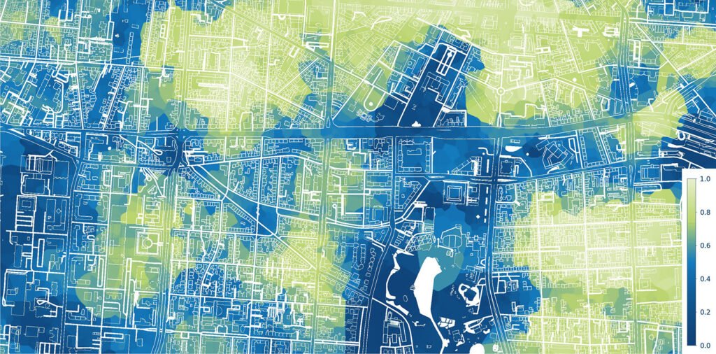
This is where the DAKIMO project comes in: Researchers at Fraunhofer IOSB in Karlsruhe have developed an AI-based system for predicting the availability of shared means of transportation, including factors such as live data on traffic conditions. The forecast calculates the likelihood of finding a bike or electric scooter to rent at a certain time at a given location. Project partner raumobil GmbH uses the forecasts for intermodal routing, meaning that a mobility app recommends connections from the starting point to the destination with predicted availability factored in. The project partners’ goal is to extend the regiomove app launched by Karlsruher Verkehrsverbund (KVV), the Karlsruhe transport authority, in making intermodal route suggestions a reality.
The objective is for users of the app to be able to obtain customized suggestions for modes of transportation that are an optimized fit for their individual needs and the chosen route, depending on the present situation.
“For transportation to be intermodal and thus more eco-friendly, it needs to be simpler, more reliable, more flexible, and easier to plan for,” says Jens Ziehn, project lead at Fraunhofer IOSB. “Our AI forecasting feature recommends the optimal means of transportation to reach the destination in each individual case, including for the different segments of the route, without overcomplicating things. Bookable vehicles, including car sharing cars, are displayed at both the start and end of the trip.” The AI steps in when humans lose sight of the big picture, for example because a bus is stuck in traffic or there are no longer any shared bikes available at the last stop.
“Forecasting is possible because the AI uses small geographical cells and short time intervals to calculate short- and long-term probabilities of the availability and expected number of sharing vehicles, based on open data sources such as data from public transit and historical data on aspects like the position of shared bikes,” adds Reinhard Herzog, who leads the Modeling and Networked Systems group at Fraunhofer IOSB.

Expanded new data standard for the transportation transition
The AI forecasting feature is to be incorporated into the international, globally applicable Sustainable MobilityBikeshare Feed Specification (GBFS) — a set of real-time specifications for public data that serves to provide traffic information such as location data for consumer-oriented applications. A one-year evaluation phase is currently in progress.
The response from the public has been positive, as was shown by a more than 1,500-person study conducted as part of the project. Nearly 90 percent of participants view AI-based predictions for shared means of transportation as helpful or very helpful.


Leave a Reply